Unuvun: Difference between revisions
Unuvun Rain (talk | contribs) No edit summary |
Unuvun Rain (talk | contribs) No edit summary |
||
| (4 intermediate revisions by 2 users not shown) | |||
| Line 1: | Line 1: | ||
{{Place | {{Place | ||
| name = Unuvun | | name = Unuvun | ||
| location = [[Htaevic Rouge]] | | location = [[Htaevic Rouge]] | ||
| part of = [[Unuvi Archipelago]] | | part of = [[Unuvi Archipelago]] | ||
| Line 23: | Line 22: | ||
== Geology == | == Geology == | ||
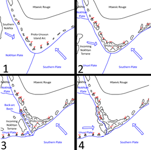
[[File: | [[File:Unuvun_Tectonic_Evolution.png|thumb|left]]The Unuvun archipelago has a complex geological history. It began as an island chain accreting off the southern coast of Delezia. A large terrane split off from Nokhta and began traveling in the direction of the young Proto-Unuvun. At around the same time, a back-arc basin formed and the volcanic arc of Proto-Unuvun migrated westwards. The Nokhtan terrane then made contact with Proto-Unuvun around modern-day Yuuvei and around its southern end, forming the Pacific Lake and the western mountain range. The north of Unuvun's left peninsula is still dominated by active volcanoes fueled by the subducting ancient oceanic crust of the Unuvun plate. Meanwhile, the Hsuvei Plain is overriding the Delezian plate and closing the Pacific Lake. Should current trajectories continue, the Pacific Lake will cease to exist and The Flow may continue to widen slightly. | ||
=== Pacific Lake === | |||
The Pacific Lake has an unusual origin as it is the product of a back-arc basin and thus has a seafloor bottom. In its southern portion it reaches a maximum depth of 1942 meters. | |||
== Ecology == | == Ecology == | ||
| Line 32: | Line 32: | ||
== History == | == History == | ||
''Main article: [[History of Unuvun | ''Main article: [[History of Unuvun and the Nautical Peace]]'' | ||
http://i.imgur.com/I31jDG1.png | http://i.imgur.com/I31jDG1.png | ||
Latest revision as of 15:27, 31 October 2023
Unuvun
Geography
Administration
Demographics
The island of Unuvun is the principal island in the Unuvi Archipelago. Located on the southern rim of Delezia-Hazele, its climate is dominated by the global circumpolar current, which bring torrential amounts of rain to the western plains of the island. It is one of the cultural hearths of Pavala as it was here that the Udàshe developed.
Etymology
The name Unuvun is an endonym, derived from the Old Unuvi phrase un u vun (lit: 'land at corner'). Though, it is technically an exonym as the literal translation was adapted from the name commonly used by other states in the Htaevic Rouge.
Geology

The Unuvun archipelago has a complex geological history. It began as an island chain accreting off the southern coast of Delezia. A large terrane split off from Nokhta and began traveling in the direction of the young Proto-Unuvun. At around the same time, a back-arc basin formed and the volcanic arc of Proto-Unuvun migrated westwards. The Nokhtan terrane then made contact with Proto-Unuvun around modern-day Yuuvei and around its southern end, forming the Pacific Lake and the western mountain range. The north of Unuvun's left peninsula is still dominated by active volcanoes fueled by the subducting ancient oceanic crust of the Unuvun plate. Meanwhile, the Hsuvei Plain is overriding the Delezian plate and closing the Pacific Lake. Should current trajectories continue, the Pacific Lake will cease to exist and The Flow may continue to widen slightly.
Pacific Lake
The Pacific Lake has an unusual origin as it is the product of a back-arc basin and thus has a seafloor bottom. In its southern portion it reaches a maximum depth of 1942 meters.
Ecology
The island can be mainly divided into three separate sections: The flat southwest, hilly north-central and fjord-carved east. The southwest plains, mainly the Hsuvei Plain, have long been developed into an agricultural heartland. However, forests of indigenous <redwood trees> still remain in the hilly north and central regions, reaching upwards of a hundred meters in height. The vast majority of the trees on the island are evergreen, and there are numerous different species of fruits trees that have been cultivated.
History
Main article: History of Unuvun and the Nautical Peace